Israel has always pressed hard to keep American satellite imagery firms from releasing high resolution photos of the Jewish state.
By Pesach Benson, United with Israel
After two years of making highly detailed satellite images of Israel available, Google has resumed blurring the images, Haaretz reported on Sunday.
Israel has always pressed hard to keep American satellite imagery firms from releasing high resolution photos of the Jewish state.
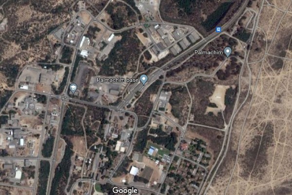
The fear is that more detailed images could be used by terror groups to better target critical Israeli infrastructure, such as the Dimona nuclear reactor, Haifa’s petrochemical facilities, the Palmachim air base and spaceport, or other sensitive sites.
Satellite images are commonly used to help people navigate between cities, assess regional planning, help humanitarian organizations efficiently evacuate people from disaster zones, track the effects of climate change, study geography, or simply plan a hike.
Satellite imagery of Israel is regulated by the Kyl-Bingaman Amendment. The resolution specified that only objects two meters or larger could be seen and that anything more detailed required federal authorization.
But in 2020, the U.S. Commercial Remote Sensing Regulatory Affairs Office changed the regulations to allow clear photos of images as small as 0.4 meters.
Google Maps and Google Earth were updated to show Israel higher resolution.
But Haaretz now reports that for reasons which aren’t clear, Google has returned to using the less-detailed images of Israel. The paper even displayed examples of current and previous images to contrast the dramatic change in clarity.
NOW in English
Google again blurring out satellite images of Israelhttps://t.co/C8f9JJsTZ8 pic.twitter.com/AZSpsXmnwq
— avi scharf (@avischarf) October 2, 2022
However, Google’s changes have not been consistent. Haaretz noted that while areas such as the Dimona reactor, Ben Gurion Airport and entire neighborhoods in the Sharon region north of Tel Aviv are blurrier, “some of Israel’s highly-classified defense facilities were left at higher resolution, including the Haifa Port.”
Google did not respond to the paper’s queries.
Haaretz also noted that there are technical work-arounds for people to see the removed higher resolution images.
The paper also noted that other satellite imaging services, such as Mapbox and ArcGIS, continue to make high resolution images of Israel available.
In 2021, when the first high resolution images of Israel became available, Harel Dan, an expert in satellite mapping told Haaretz that the wider availability of the images wouldn’t significantly raise the risk of attacks. “All this information was available to anyone who really needed it and was willing to pay for it.”
In August, Russia successfully launched an Iranian spy satellite that would give Tehran the ability to monitor Israel, American troop movements and sensitive facilities throughout the Mideast and Persian Gulf.
The satellite’s camera is reported to have a resolution of 1.2 meters, which is short of Western capabilities, but a marked improvement for Iran.
Ukraine has reportedly used information from commercial satellites to track Russian military movements.
Images from commercial satellites are not as detailed as from government satellites, but information can be more easily shared without security restrictions.