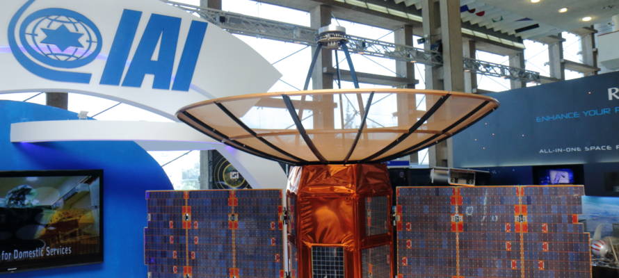
The lead researcher into Israel’s first environmental research satellite will create a national archive of images, which, he says, will serve as an important climate change tracking resource.
Israel will launch its first environmental research satellite, VENuS, into space on August 2 on the “Vega” launcher from French Guiana. The satellite, which stands for “Vegetation and Environment Monitoring on a New Micro Satellite,” is a flagship project of the Israel Space Agency (ISA) and its French counterpart, CNES.
Ben-Gurion University of the Negev said in a release that the new satellite will be Israel’s first scientific observation satellite to conduct agricultural and ecological research. Professor Arnon Karnieli, head of the university’s Remote Sensing Laboratory at the Jacob Blaustein Institute for Desert Research in Sde Boker, is the lead Israeli researcher on the project, together with French counterpart Dr. Gerard Dedieu of the French center for studies on space, CESBIO.
The satellite is expected to launch from the Guiana Space Center in Kourou at 4:58 a.m. Israel time on Wednesday.
The university said that environmental research satellites have become increasingly important in recent years in light of rising environmental hazards such as population overcrowding, the dwindling of arable land, pollution and natural disasters. The satellite will track agricultural fields and other natural areas, recording data about the status of the land, foliage, forestation, agriculture, quality of water sources, and more. The satellite will transmit images every two days of the chosen research sites worldwide to Karnieli and Dedieu. The first images are expected to be available to researchers on November 1.
Israel Renowned for its Courage and Innovation
Science, Technology and Space Minister Ofir Akunis commented, “Israel is renowned the world over for its courage and innovation, elements which are expressed in the technological development of VENµS as well. We are filled with pride to see this long-awaited project of the best engineers and researchers in Israel led by the Israel Space Agency and the French Space Agency (CNES) reach fruition.”
The micro satellite, built by Israel Aerospace Industries (IAI), will weigh 265 kg at launch and will enter a geo-synchronous orbit at a height of 720 kilometers within two days of the launch. The first signal from the satellite is expected five and a half hours after the launch. The satellite will orbit the Earth 29 times each 48-hour cycle and is expected to remain in orbit for 4.5 years, after which the satellite will move to a lower orbit 410 kilometers from Earth.
VENµS is equipped with a special camera that scans the earth in 12 wavelengths, far more detail than the human eye can discern. According to Prof. Karnieli, this will enable the scientists to better quantify the state and dynamics of vegetation at the chosen research sites.
“The combined unique characteristics of the satellite, including a high spatial resolution of 5 meters, high spectral resolution of 12 narrow bands, and high revisit time of two days, is essential for monitoring agricultural crops in accordance with the concept of ‘precision agriculture’,” says Karnieli, “This concept allows the farmer to see the spatial and temporal changes of his crops not just on the scale of the entire field, but on an intra-field scale of small plots. It helps the farmer to conserve his resources and to protect both the land and groundwater from surpluses of water, fertilizers, and pesticides.”
Karnieli will create a national archive of the images, which will be available for research purposes but not commercial ones. In the future, they will serve as an important climate change tracking resource as images from future satellites will be able to be compared to the VENµS images.
By: Andrew Friedman/TPS
