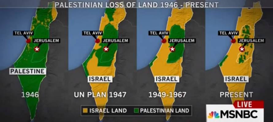
US news network MSNBC presented misleading and inaccurate Palestinian propaganda maps as fact in a segment that justified the current wave of Palestinian terrorism against Israelis.
MSNBC’s “Middle East expert,” Martin Fletcher, presented a series of maps created as Palestinian propaganda for historical fact in a segment on Sunday.
The news network apologized for the mistake, but is continuing to broadcast the inaccurate maps. MSNBC previously reported that Israeli security shot an unarmed Palestinian man who was actually a knife-wielding terrorist.
The maps purport to show the progression of the Israeli “occupation” from 1946 until 2013, but are full of inaccuracies and lies of omission.
https://youtu.be/ZxaM5tjFyAw
By failing to distinguish between land ownership and governmental authority, the maps erase the existence of all Arab-Israeli landowners and some Palestinian landowners, creating a highly vivid, yet false picture of Arab dispossession.
“I must say it’s pretty shocking when you present it this way,” Fletcher said. “What it clearly shows is that if there’s no peace agreement between the Palestinians and Israel, more of those green areas, more of that Palestinian land will be eaten up by Jewish settlements.”
The first map claims to show Jewish vs. Palestinian land ownership in yellow and green, respectively, prior to the declaration of the State of Israel. Less than half of the land labeled “Palestinian land” was privately owned. The rest was public land, administered by the British Mandate authorities and by the Ottoman Empire before them. The use of the term “Palestinian” to refer to Arabs prior to 1948 is also an anachronism, one that disingenuously implies that Jews have no valid claim to their ancestral homeland. In addition, the term “Palestinian” before 1948 referred to both Jews and Arabs alike.
The next two maps in the series show the proposed borders in the 1947 UN Partition Plan and the armistice lines prior to the Six Day War in 1967. It is strongly implied that Israel increased its territory through land grab wars, when the reality is that Israel was attacked by five Arab countries in 1947 and poised to be attacked by 3 Arab armies in 1967. Public land is still labeled as Palestinian land, even though it was under Egyptian and Jordanian authority.
The last map claims to show the current situation as of 2013. Public land and Areas B and C in Judea and Samaria are have gone from green to yellow, despite there being very little change to actual land ownership. Parts of Gaza are labelled as Israeli, despite the fact that the last Jew was expelled from Gaza in 2005 and the territory has been under Hamas terrorist rule since 2007.
“Although right now there is a freeze on settlements by Israel because there’s so much international pressure, the Palestinians say ‘If we don’t have peace soon we won’t have a Palestine left,’” Fletcher claimed.
This is not MSNBC’s first gaffe in reporting on the latest Palestinian violence against Israel. Over the weekend, reporter Ayman Mohyeldin claimed that Israeli security had shot an unarmed Palestinian man near the Damascus Gate in Jerusalem, despite images clearly showing that he was a terrorist armed with a knife.
By: Sara Abramowicz, United with Israel