An Israeli researcher combats false claims that Arabs are indigenous to the Land of Israel and reasserts the truth that this land historically belonged to the Jewish people.
By Sheri Oz, United with Israel
The media, and even academic publications, are replete with claims that Israel is “occupying” what they refer to as “historic Palestine,” meaning Israel, Gaza, and Judea and Samaria (or, in their terms, the West Bank). It is ineffective to try to engage in long discussions of history and facts showing that it is the Jews who are indigenous to the land. We all know that feelings speak louder than facts, and pro-Palestinian propagandists use emotion in a way that has so far stymied Israeli attempts to set the record straight.
We also know that one picture is worth a thousand words.
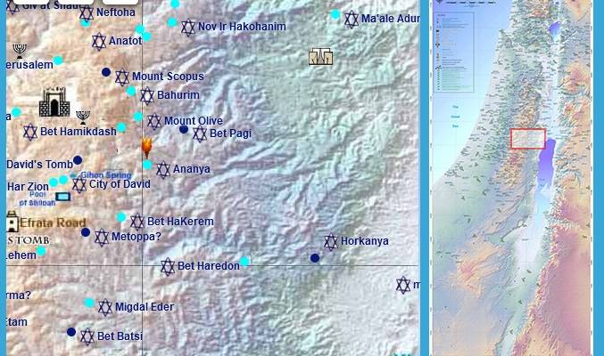
And now we have that picture – it is a map, in fact. A map of approximately 700 ancient Israelite settlements and holy sites all across the entire historic Land of Israel. Two hundred additional sites that have been discovered by archaeologists but not yet identified will also be added to the map.
The map was developed by Michal Eshed and uploaded onto the Internet. It is in Hebrew and English, with Arabic to be added in the future. Her website is found on eretzil.net where eretz means ‘the Land’ and IL is the international short form for Israel.
When working as a psychologist for the Samaria Regional Council, Eshed drove daily from Ramat Hasharon, near Tel Aviv, to work in Samaria. She would pass by the Kafr Qasem and knew that it was originally a Jewish town from the time of the Second Temple described by Titus Flavius Josephus, then known as Kfar Kesem. Always interested in history, she grew curious, wondering about other Hebrew or Israelite communities that existed before the contemporary Arab villages.
Looking for maps or other documentation in a number of university libraries in Israel, she found a few maps ,but the most important one was produced by the late Hebrew University of Jerusalem historical geographer Professor Michael Avi-Yonah from the 1930s. It was an old map but he had done the major preliminary mapping. Eshed used this map as a basis for continuing the work of documenting ancient Israelite villages and holy sites and the Arab settlements that were established alongside or in place of them.
Currently a PhD student in the Land of Israel Studies and Archaeology Department at Bar Ilan University, Eshed continues to develop this project. After intensive work, a list was produced with over 700 ancient Israeli Jewish settlements, each one of which has geographic landmarks associated with it. To this list Eshed added the Arabic names that were given to these sites following the Arab Muslim Conquest, clearly indicated on the map.
‘A Desire to Get to the Historical Truth’
Eshed explained why she decided to embark upon this demanding project: “My motivation was a desire to get to the historical truth and to publish the results of my work on a map. I saw there was a phenomenon still not exposed. Almost every Arab village is sitting on an ancient Israeli village. Nobody is talking about this. You cannot find this on any signs, not at the entrance to Arab villages, not at national parks; there is no indication there was once an Israelite town in these places.”
There is a debate raging concerning the geographic history of the Land of Israel and a lot of invention of “history.”
It is important to make sense of the historic sequence of settlement in the Land of Israel: to show where all the ancient Israelite communities were and to document the Arab occupation of Israel from the 7th Century CE and the comprehensive Arab Muslim settlement on Israelite settlements both alongside Jewish residents or in their stead.
Eshed says she was surprised to discover that the word Kafr, that is part of many Arab village names, such as Kafr Qasem, Kafr Qara, Kafr Manda, etc., is not an Arabic word at all. It is an Arabized version of the Hebrew word for village, Kfar. The word for village in Arabic is Qar-ye.
“This is irrefutable evidence”, says Eshed, “for the phenomenon I described and whenever you see an Arab town named Kafr “X”, therefore, you know it was originally a Jewish village.”
Looking at her map, one can see that many of the names for Arab towns in the Land of Israel are simply the same names as the ancient Israelite village pronounced with an Arab accent, such as: Bet Jibrin/Beit Govrin, Yata/Yuta, and so on.
There is no argument that Israel’s War of Independence resulted in the emptying of many Arab villages.
However, residents of these villages were either descendants of settler-colonialists from the Arab Conquest or more recent economic migrants to the Land.
It is important to combat the falsehood that claims that the Arabs are indigenous to the Land of Israel and to reassert as strongly and as often as necessary that it is the Jewish People who are indigenous to the Land and the Arabs are the occupiers. Michal Eshed’s map of ancient Jewish sites helps us set the record straight.
Bring Joy to Israeli Soldiers - Send Winter Care Packages!

We are honored to thank the young men and women of the IDF who risk their lives every day to defend the citizens of Israel.
Join us in sending winter care packages and personal notes of support to Israeli soldiers who are out in the cold all day.
Warm up a soldier's heart with essential winter wear including fleece jackets, hats, gloves and more. Keep an entire unit warm!
THE SOLDIERS REALLY APPRECIATE YOUR LOVE AND CONCERN!
Click Here to Send Your Gift and Personal Note to Israeli Soldiers